 Live Music Archive
 Librivox Free Audio
 Metropolitan Museum
 Cleveland Museum of Art
 Internet Arcade
 Console Living Room
 Books to Borrow
 Open Library
 TV News
 Understanding 9/11
tv Fox Morning News FOX October 30, 2012 7:00am-9:00am EDT
7:00 am

from 5-15 inches of snow. good morning, everybody. i'm tony perkens. >> i'm allison seymour. there are still many closings this morning, metro closed again. the transit agency is assessing the damage and we are hoping to get an update on when service will resume later today. >> the federal government offices are also closed again, so are most local government offices, and schools. >> hundreds of thousands of people are left in the dark this morng, in dc, maryland, and virginia, and here are the current numbers for you. dominion, more than 115,000 customers out in northern virginia. pep co right now dealing with about 25,000 outages. bge has around 84,000 outages. and montgomery, prince george's, cal vert, ann arundel and howard counties. so now potomac edison and smeco are also experiencing significant outages this morning. >> so let's find out what is happening. i know it is raining in much of the area. tucker barnes can give us the latest on the forecast and tell us what is happening with
7:01 am

sandy. hey, tucker. >> good morning, tony. good morning, allison. good morning, everybody. things have gradually been improving out there. although i wouldn't say all clear yet. heavy rain across the region and still the potential for some winds gusting to about 40 to 50 miles an hour. not done yet but things should gradually get better today. a live look at the radar and you can see that we've still got plenty of rain across the region, including a pretty good little batch there of rain that is just developed in the last 15 minutes, just north and west of the city, working down toward bethesda, and that will be working inside the city here. in fact, it is now down toward old town alexandra as well. plenty of rain across the region. continues to fall. and rain totals starting to get very impressive numbers and all three area airports yesterday had record rainfall for the day including 4 1/2 inches out of dulles. a lot of rain out there. saturated soil. that will cause some additional flooding issues later today. let me show you what is going on. big picture here. let's swih maps and you will
7:02 am
see the big spinout there, just an incredible sight, and we're just about 100 miles south of what would be the center of sandy if it were still intact and you can see it is pulling moisture off the ocean and bringing a lot of mountain snow to western virginia and western maryland. so this will gradually push off to the north and west through the course of the day and as it does so, we should see our winds gradually subside and the shower activities lighten later today. 23 in leonardtown. 35 in martinsburg. we can expect winds gusting to about 45 to 50 miles an hour today with rain showers through the noon hour. high temperatures on the cool side. only about 47 for a daytime high. more weather in just a moment. let's get traffic and the latest from julie wright. good morning, julie. >> as you can imagine, it is very much a busy drive out here around town. we have issues to deal with along streetville road at 267
7:03 am

and due to flooding. georgetown pike as expected dealing with tree debris down in the roadway. and again, 66, major arteries are not looking too bad. and getting there is going to be the headache for you and again, if you can stay put and let the cleanup continue from this morning or from the debris if you will, that would be the better bet. again, we are dealing withstanding water and that's affecting the commute right now, along 214 at rebba road. over to the mall, it is blocked off in this area. windy conditions continue to shut down the bay bridge. no one coming to or from the baybridge at this time. 198 is reopened in each direction at old gunpowder road. a portion of new hampshire is blocked off due to wires down in the roadway. 29 shut down due to flooding in four corners. you get the idea of what i'm talking about. the laundry list continues to build as more people get out and abouton the roads where wires are down and where there is flooding. signal lights are dark as well. flooding in the district affecting your commute at 15th street at constitution avenue. if you can stay put and let the
7:04 am

authorities get on the roads and clean this mess up for you, metro still suspended service until further notice. they're hoping to give us an idea of when they will restore service by noon today. we will keep you posted with the information as it becomes available. that's a check of fox 5 on-time traffic. superstorm sandy is leaving her mark on more than a dozen states with one of her biggest impacts come coming to the biggest city in the u.s. >> the new york city area hit with flooding and damaging winds and massive blaze also last night. and take a look at these dramatic pictures, a raging fire related to the storm destroyed at least 50 homes in queens, new york. this is in the beachtown of breezy point. basically one of the lowest points of new york city. the fire started around 11:00 last night, and it went to six alarms. a real disaster there coming out of the storm. >> at the height of the storm last night, several hospitals in new york city evacuated patients after power and flooding became a problem. and back-up generators failed.
7:05 am
the evacuations included 20 babies from a neonatal intensive care center. they were carried down flights of stairs still on battery powered respirators. surging water from sandy flooded several bus garages and tunnels in the city. the transit chore chairman says in the 108 years, it has never faced a disaster as devastating as last night. >> battery park city, down at the tip of manhattan, experienced flooding like it hasn't seen before. a record 13-foot storm surge. three feet higher than the previous record. >> one of the most dramatic stories out of new york yesterday remains a big concern today. a crane that snapped yesterday afternoon, still dangles from the top of a luxury hi rise building still under construction. the storm made land fall not far from atlantic city, new jersey. washing away part of the famous atlantic city board walk. a string of new jersey's barrier islands were cut off from the mainland by storm
7:06 am

surges. the storm slammed the coastline with 85 mile-an-hour winds last night. >> sandy had a huge impact north of new york. this is video of major waves along the shore at new london connecticut. some of her strongest winds were felt in rhode island, massachusetts, and connecticut. hundreds of thousands have no power in those states. and sandy did not just bring high winds and rain. parts of west virginia and north carolina are dealing with blizzard conditions. this morning the appalachian mountains are bracing for as much as three feet of snow. at least one deadly traffic accident is being blamed on those conditions. >> now, the worst of sandy may have already passed through ocean city, maryland, but the area is still seeing remnants of rain and wind. >> it took a hard hit all day yesterday. flooding streets, damaging several buildings, too. and our lauren demarco is live there this morning with the latest on sandy's impact. lauren, good morning. >> good morning to you. howling winds right now.
7:07 am

the rain seems to have let up slightly, very light drizzle but it is cold. the wind is very strong. the waves kicking up. we have high tide around 9:00 a.m. this morning. and remember that the sand has been pushed up all the way against the sea wall here, so not offering much protection. we just saw some bulldozers and a dump truck rolling down the street looking to pick up some of the debris. sure to be a lot of cleanup ahead. >> ocean city, no match for what superstorm sandy brought. right now, both bridges that head into town are closed to inbound traffic. the flood waters downtown south of 17th street are receding, but much of the area is still without power. at the height of the storm, roads were flooded, several feet deep. dozens of families had to be evacuated. boats broke loose from the dock where the storm pushed up water from the bay, pounding the town from all sides, sandbags were no defense. the severe flooding here at
7:08 am

mackey'bay side bar and grill. i'm standing in water almost up to my knees. this is right off 54th street. and the parking lot and the bay pretty much become one at this point. the town's landmark fishing pier, perhaps the biggest low. half of it is gone. washed away by the constant beating of the monster waves. >> and basically what happened is the pilings on the outer position of the pier began to buckle under the stress of the wave action it was receiving. as they began to buck, one, two, three they lost a number of pilings and they began to fall. >> the storm surge broke over the sea wall, dumping water and piles of sand on the board walk. iron fences buckled under the powerful waves. it ripped up fences bolted to the board walk, dumping them into the street. along with that fishing pier, another landmark, a gazebo off of sayer's island peer, was
7:09 am

also destroyed. completely. so that gone. i want to mention that from 62nd street all the way down to the inlet, ocean city, does remain closed to traffic at this point. that is the latest. back to you in the studio. >> all right. lauren, thank you. the heavy winds tore up parts of the roof on three buildings in alexandria. >> one is an apartment complex that has now been condemned and fox 5 holly morris just arrived at the scene. how does it look there? >> actually, it looks fine. looks can be deceiving. if you just look at the building behind me, it looks like a regular apartment building. in fact this whole complex on the street on kenmoore avenue, the power is on, a lot of cars here, but what we do know from the city of alexandra, is that building right there is condemned and that apparently on the roof, there is significant damage. so much so, that the 11 families that live in that building, or i should say lived in that building, 20 people, all had to be evacuated, and the good news is, they did all
7:10 am

fine shelter with friends and family. apparently they had a place to go. but the bad news is they don't have a place to come back to. obviously, when the building is condemned, that means they need to find a new place to live. this is one of three buildings like you said that had roof damage and that is one of those luck of the draw things. literally, there is just one apartment building, a lot of these garden style apartment building, one right after another on the street, and this is the one that got condemned. so bad news for those families. in general, in alexandria, the city is reporting that there are 10 houses that have some sort of tree damage on them. so obviously, they will be dealing with that, as the sun comes up this morning as well. and as we stand out here in the rain, the concern heading intay rest of the week, is flooding. you know, we know in old town that it floods quite a bit. the good news is they are reporting that it didn't flood, they didn't have any damage on any boats down there, but they are not out of the woods just yet. they don't want people to get too complacent. they say flooding could happen
7:11 am

and they will keep their eyes on it especially today as it continues to rain and into tomorrow and really they will keep their eyes on it through the rest of the week. so this morning, alexandria is kind of assessing the damage. there is some. not a lot in terms of what it could have been. so there is a big relief sigh of this, unless you're one of the families dealing with it firsthand. that's the latest here. back to you in the studio. >> holly morris, thank you very much. >> flooding fears forcing some people in huntington virginia to evacuate their homes last night. then, from 1900 residents in the bellview new alexandria neighborhood were put on alert, they too could be evacuated later today. crews are monitoring the situation. as of now, things are looking good. and those folks won't have to leave. but we know that things can change. especially when the sun comes up and folks start to evaluate some of those areas. >> and i think because so much of this action was last night, in the dark, we will know a lot more during the coming hours with the brighter daylight.
7:12 am

all right, it is 7:11 now. super storm sandy also having a big impact on the presidential campaign. still ahead what both candidates will be doing today instead of hitting the trail. >> and as we head to the break, a live look outside. if you're headed out there today, be aware of some road closures and some downed treeses. julie has all of that information after the break. we will also have the latest weather from tucker. it is 7:12. we'll be right back. it's my ce when i want it. you press a button, you have great dunkin' coffee. i got my coffee for the morning, i got my dunkin' k-cup packs for the rest of the day. only available at dunkin' donuts restaurants. america runs on dunkin' coffee.

7:14 am

we're spreading the word about honey bunches of oats fruit blends and their unique taste combinations. like peach/raspberry. with one flavor in the granola bunch and one on the flake. two flavors. in harmony. honey bunches of oats. make your day bunches better. would ban all abortions and contraception seemed a bit extreme. so i looked into it. turns out, romney doesn't oppose contraception at all. in fact, he thinks abortion should be an option in cases of rape, incest, or to save a mother's life. this issue's important to me, but i'm more concerned about the debt
7:15 am

our children will be left with. i voted for president obama last time, but we just can't afford four more years. [ romney ] i'm mitt romney and i approve this message. [ romney ] i'm mitt romney i'm drinkin' a dunkin' latte. i'm in love with my dunkin' latte. it is a treat. they're packed with flavor. it's my kind of latte. try the simply delicious latte everyone can enjoy. america runs on dunkin'! maryland governor martin o'malley is cancelling early voting again today but he is extending early voting on friday. in the district of columbia, the board of elections is also announcing that early voting will remain closed today. all because of course of sandy. >> and with one week until election day, that's right, one week, president barack obama and governor mitt romney are
7:16 am

suspending their campaigns for today. president obama is at the white house, and is monitoring the impact and response to superstorm sandy. aide force governor mitt romney say if anything, he will take part am some sort of relief effort. the federal government is shut down again today, but the labor department says friday's big jobs report will still be released on schedule. >> hard to believe that the election is next week. >> obviously, we were all consumed with it, and in the last few day, we have been dealing with this storm. but we will be back to it i'm sure tomorrow or thursday. >> there we go. >> uh-huh. >> good morning. >> we're still not out of the woods with this. the impact of the storm is just absolutely amazing. so we are going to get right to it and let people know exactly what is going on. let's look at the infrared satellite shot of what was hurricane sandy. now it is actually about 90 miles west of philadelphia. but you know what? take a look at the wide area still being impacted by the
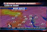
7:17 am
storm. heavy rainfall, as well as very strong winds. a lot of storm surge. still all happening. so this storm really huge. and now we have some heavy rainfall right here through the dc area that has started to move in. so be prepared for this along the i-95 corridor here and the rain is continuing to come down and lasting through at least tonight. and maybe creeping a little bit into the early hours of wednesday as well. wind gusts, 29 mile-an-hour wind gusts right now at the airport. 22 at quantico. the same at fredericksburg. prompting high wind warnings mainly to the areas to the north and east of us. that is in effect right through until 8:00 tonight. here is a look at what is happening across areas in terms of sustained winds. up to 20 miles an hour sustained winds for our area. to the west is what i want to talk about. we have windy conditions and a blizzard warning in effect. 6-12 inches of snowfall above 2,000 feet. heaviest snowfall for this will be into tonight and i'm looking at this even increasing in
7:18 am

accumulation. they've already got quite a few high numbers there. for today then, 47 degrees. looking at the rain and the gusty winds. mostly cloudy and windy as we move through the day tomorrow. we will see a chance of some of that rainfall lingering and creeping a little bit into early wednesday morning. so we will keep a close eye on that for you. here are how things are wrapping up. winds gusty through wednesday. the rain tapers off overnight into wednesday morning. and it will stay dry thursday, through the weekend. so that is at least good news. but our temperatures are going to continue to stay below seasonal all week. we should really be into the 60s, but unfortunately, our temperatures are going to be just sticking around into the low to mid-50s. pretty much all week long. your overnight lows, a little bit on the cooler side as well. i know some of you probably know people who are without electricity right now. so that is not doing very well in terms of the power being off, and at night, it is really getting chilly with the temperatures down to the 40s as it was last night. so make sure you check on your
7:19 am

neighbors especially elderly neighbors to make sure that they're doing okay. but overall, we will finally get rid of all of this as we move into thursday at least. let's check in with julie wright. >> good morning. cleanup conditions out here around the capital beltway. and of course traveling into dc. flooding issues to deal with especially those along south dakota avenue between new york avenue and bladensburg road. along route 1, rhode island avenue, between 7th and north castle street. 15th at constitution is blocked off as well because of flooding. we have 355 tied up between doctor perry and route 810 due to flooding. we have -- 80 due to flooding. we have tree damage near farther hurley. that is cleared at this time. but in maryland, overhead signs warn you that maximum speed is 45 miles an hour. if you have to make a trip out and about this morning, make note of that. flooding woodburn south of gallows. burke lake at rolling road.
7:20 am

there is tree debris between the georgetown pike. so the list continues to build this morning. for those continuing out and about around town. please, again, if you encounter an intersection with a traffic light not working, treat it as a four-way stop and of course if you run into an intersection with a lot of water, do not attempt to travel through it. we've already seen some pictures off of twitter this morning where people have attempted to make that and unfortunately have not. so again, remember the song is do not drown, turn around. keep that in mind on the roads. that's a check of fox 5 on-time traffic. >> thank you very much, julie. a leak at at water park in maryland is sending about 2 million gallons of raw sewage rushing out every hour. it is all happening at little patuxent river reclamation plant in howard county. the overflow was caused by a power outage. bge has made the plant a top priority to get back on line. no mandatory evacuations right now but residents are asked to avoid the little patuxent river south of route 32. hundreds of thousands in
7:21 am

the dc region are waking up in the dark this morning. out next, the latest on the power outage swathe. >> plus, a live look at the damage sandy caused in lower maryland. that and much more coming up on fox 5 morning news. it is coming up on 7:21. anncr: seven-hundred-thousand jobs. that's what the plan george allen supports... would cost our economy. newspapers called it "economically destructive." like allen's votes to give tax breaks to companies... that ship jobs overseas, his economic plan would... help big corporations, devastating the middle class. allen even voted against tax breaks for small businesses. virginia can't afford to go back to george allen.
7:22 am

the democratic senatorial campaign committee... is responsible for the content of this advertising.

7:24 am

right now on fox 5 morning news, check this out. the scene last night in lower manhattan. a transformer exploding. no doubt contributing to the -- wow, that's pretty big. contributing to the hundreds of thousands in new york with no power this morning. wow. all right, the lack of power is also a problem closer to home. hundreds of thousands in dc, maryland, and virginia, are waking up in the dark and the cold. >> let's get an update now from pep co. joining us on the phone, just as he did yesterday, probably about the same time is clay anderson. clay, good morning. >> good morning, allison.
7:25 am

good morning, tony. >> where are we now with the power and pep co's response? >> where we are right now, we have about 25,400 customers that are out. that includes about 17 thousand in montgomery county. prince george's county, 4600. and in the district of columbia, about 3,600. the peak of the storm overnight, about 41,000 customers were out there, at the peak, so we have made progress overnight as safety permitted crews were out. and overnight and throughout the day. again safety permitting. >> sure. i would have to imagine, obviously, anyone who is without power, they don't like it, and you know, you're going to work very hard to get power restored to everybody as quickly as you can, but i would imagine you have to be somewhat relieved that these numbers are not higher. >> relieved is the word, tony. pep co is relieved and quite fortunate that the storm made the turn when it did.
7:26 am

again, 100 miles makes all the difference. if it would have been just a degree or so, and you know what i'm saying, just to the south and east, we would be looking at a lot more outages, much more significant and possibly dangerous situation. but here in the washington metropolitan area, for pepco, 25,000 customers out, or 25,000 that need their lights but it don't have been easily a lot more. >> i know it is early, clay but folks want to know what is the timetable they're looking at here as far as restoration? >> we should be giving out individual estimated times of restoration or etr's sometime today. the good news the crews that we did bring in from out of state are still here. they will be moving out shortly, along with our crews, so 1400 men and women are going to be stretched across the area. we know that montgomery county and areas of potomac, hard hit, a lot of down treed and wires
7:27 am

in those areas. so we have w assessment. we will continue to assessment and we're learning where the problem spots are. and we will restore them. accordingly. throughout the day. >> the etr, i will use that with you from now on. i feel a little cooler now. >> yes. estimated time of restoration, etr, we can work with that. >> clay anderson, thank you very much for your time this morning. we know you folks are busy and good luck with the rest of the restoration. >> thank you. be safe. >> you too. 7:27 now. tuesday morning. and still ahead the death toll from sandy along the east coast continues to rise. with tragedy striking in maryland last night. we're live in laurel after the break. >> as we head to the break, we want to take another live look outside, luckily, so much is shut down today. the government, many businesses, schools, that it is going to aid in the effort to get all of this work done. a live look at the roads. i-495. at connecticut avenue. and not very busy but the roads are slick. be careful. we will be back in a little bit. it is 7:27.

7:29 am

a west virginia casino launching the biggest ad barrage ever. don't be misled. the washington post says question seven is just... common sense. it'll create 4,000 permanent jobs. and stop maryland from losing millions to other states... every year. that's why business, labor, and teachers all support... question seven. and so does the washington post. vote for question seven. it's just common sense.
7:30 am

♪ [ multiple sounds making melodic tune ] ♪ [ male announcer ] at northrop grumman, every innovation, every solution, comes together for a single purpose -- to make the world a safer place. that's the value of performance. northrop grumman. welcome back. 7:30. superstorm sandy slammed ashore last night killing at least 16 people. more than 5 million are in the dark this morning and school from virginia to maine are
7:31 am

closed again today. there are states of emergency declared in eight states and in new york city, transportation officials are worried about sea water flooding some subways. >> it is called a superstorm. it lost hurricane status but it didn't stop her, right? it was a hybrid. part tropical storm. part nor'easter. >> and still a very big storm as it is now. >> s a mave storm. we will take another look at it on the satellite picture and any time you're talking about blizzard condition, you're not just talking about a tropical storm. so you know, it is amazing. we have heavy rain now working into northwest side of the district. just stepped outside, and you will notice that the rain is really coming down here across northwest washington, and up towards bethesda, and north side of the beltway here, and there you go, really good rain and that is working through the city here shortly. and just be ready for some locally heavy rain here over the next 15 minutes to a half hour. all right. out to the east, we have more
7:32 am
rain shower activity out along the western shore of the bay there. and you can see widespread rain showers continue for much of the area. and then it will be with us for the next several hours. later today, the rain rates should lighten up and it should just be scattered showers as things gradually improve around here. during the course of your tuesday. and tony mentioned the big storm out there. check out how massive the storm is. 500 miles across with tropical force winds. it is still pulling moisture even into this hour up into new england. look at that twirl. and thin around the backside, where the air gets cold enough to support it, we've got winter weather around west virginia and parts of ohio at this hour. where they're actually seeing snow flying and of course blizzard warnings continue for parts of west virginia and western maryland. the whole system is going to gradually change here. and the center by the way is in central pennsylvania and off to the north and west during the course of the day today. and we should gradually see winds subside and see the rain rates really start to lighten
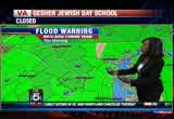
7:33 am

up later today. speaking of rain, a couple of flooding issues and we will just show you one big map here that shows a flood warning this morning. but the bottom line is we have some issues with some of the local creeks and rivers which have been overflowing their banks here with the locally heavy rain. we picked up over the last 24 hours. and the second part of the flooding issue is going to be coastal flooding. now, what happened yesterday, we call it a blowout. the winds were so strong out of the north and west, it pushed the water out of the bay, and down the potomac. today, the winds shifted out of the south and west and out of the south later today and push the water back up the bay. so we're very concerned we will get pretty good flooding with high tide later this afternoon in annapolis and old town alexandria under a threat of good tidal surges as well. and the northern tier of the chesapeake. so that will be the next concern here later this afternoon and tonight. so we're not quite done with the storm yet. other mentions, it is cool out there. it is cold in fact. 43 in washington. if i were to show you the wind chill index. low 30s right now.
7:34 am

41 in leonardtown. and 43 in fredericksburg. very chilly out there. and 47 the daytime high. and winds south and west, 20 to 35. gusts to 50. that is a little better than last night. rain likely. of course it is still windy and breezy this afternoon. things will gradually get better. on the seven-day forecast, things gradually get better. a lot of clouds tomorrow. but sunshine with highs in the mid-50s toward the end of the week and right now the weekend looks dry and quiet. we will take it. a look at weather. let's see the trachg and find out what -- traffic and find out what is happening happening with julie wright. >> authorities tell me about 143 secondary roads between loudoun and fairfax and prince william counties remain shut down due to storm-related issues, meaning flooding or trees down, wires down, storm damage, anything like that. signal lights are not, bog, that sort of thing. -- are not working, that sort of thing. about 140 signals in fairfax county alone are not working. if you go to a intersection where the signal light is not working, you need to treat it
7:35 am

as a four-way stop. hopefully you're waking up with power. but if you come up to an intersection where you find standing water, don't go through. it instead, turn around. still dealing with flooding. and tree debris to deal with. georgetown pike. at the beltway. tree debris earlier on the bw parkway, near salt run. that should be cleared. but wstill have issues with the standing water to the east side of town along 214 over near the mall. 450, closed off because of flooding. windy conditions continue to close the chesapeake bay bridge. no one is able to get by at this time. earlier problems to deal with at 198. all of that activity has cleared. but route 1 is still tied up because of the flooding this morning. accident activity. southbound 450 at the bw parkway, long gun. 410, new hampshire avenue, wires down. 29 remains blocked off between four corners between university and lockwood due to standing water. south dakota avenue shut down near bladensburg road because of standing water. as well as 50th street and constitution avenue.
7:36 am

if you can stay put this morning, we strongly encourage you to do so. and when you're out and about highway speeds are restricted to no more than 45 miles an hour. that's a check of fox 5 on-time traffic. >> as we mentioned, sandy is now a superstorm. it moved through annapolis yesterday afternoon. a lot of store owners prepared with sandbags and the harbor did not flood. the wind pushed the water away from annapolis and even at high tide last night, the docks were not under water. thank goodness for that. >> all of the rain saturated the ground though making it easy for trees to topple over. >> the high winds did just that. some of our homes in the area have major damage from trees falling on them. fox 5 melanie has more. >> good morning, tony, we are here, at 7th street and main street, at the top of historic old town laurel and i want to take a look at the trees behind me over here on 7th street. you can see what looks to be
7:37 am

two branches but it has been split. this is a tree that hasn't come down yet. but it is going to at some point, whether by choice or by force. we're hoping that tree crews can get to it first. so that it doesn't damage the power lines and the poles that you see here. the city of laurel had about a dozen trees come down last night. including four of them that hit homes. and that includes a major one on conty road in laurel. very large tree came down. right about the height of the storm. 6:00 in the evening. and the house was made uninhabitable because of all of the damage to the roof. fortunately, there were no injuries. but people there did need to evacuate very quickly. and again, no injuries. but they were left with some very expensive repairs. >> that's pretty much the scenario we have. and a couple of other houses that were struck, the porches were crushed, and in some cases, we had some branches, large branches that came down on some cars and blocked the
7:38 am

roads. but we had a lot of large branch, small trees, blocked roads throughout the laurel area. and that's what we had to deal with for the most part. >> and flooding also certainly on the minds of people. there were about four roads that sort of overwashed flooding here, here and around laurel, where people could not get through. and also many roads around the area where branches are down across those roads as well. so travel definitely, if people are trying to get out this morning, it is still a little tricky. especially because we don't know exactly what the extent of the damage is, until full sunlight comes up. one of the things that i was told, sort of reminding people, that once the storm passes through, it doesn't mean that all of the possibilities for damage are over. we're still watching very carefully. patuxent river flows right behind man street here for a little. there is a reservoir that is very close. and as we get all of this rain
7:39 am

that is going to be rushing down from the north, we are expecting that there will be more flooding in the days to come. so they're standing by looking for that. i also heard tony and allison, you guys were talking about the overflow at the sewage treatment plant in howard county. i talked to pete and asked if that possibly could cause any issues here in prince george's county and the city of laurel and he made some phone calls on that and he says it is a little further up and doesn't expect it to impact residents here in laurel. but those are the sorts of things people will be dealing with for several days after the storm finally wraps up. back to you. >> melanie alnwick, thanks. coming up, the rain is letting up a little bit in rehobeth beach but still a big cleanup ahead. fox's doug luzader will be checking in after the break. and the coast guard to the rescue, after the crew of a famous tall ship replica abandons during sandy. that story after the break
7:40 am

next. >> as we head to the break a live look from western maryland from one of the traffic cams out there. not many people on the roads because they got a lot of snow. we will tell you a lot about that, too. it is 7:39. we'll be right back. launching the biggest ad barrage ever. don't beisled. the washington post says question seven is just... common sense. it'll create 4,000 permanent jobs. and stop maryland from losing millions to other states... every year. that's why business, labor, and teachers all support... question seven. and so does the washington post. vote for question seven. it's just common sense. we were told to build a 30-foot stage. gathered the guys and we built that 30-foot stage, not knowing what it was for. just days later, all three shifts were told to assemble in the warehouse. a group of people walked out on that stage and told us that the plant is now closed
7:41 am

and all of you are fired... i looked both ways, i looked at the crowd, and...we all just lost our jobs. we don't have an income. mitt romney made over 100 million dollars by shutting down our plant and devastated our lives. turns out that when we built that stage, it was like building my own coffin, and it just made me sick. [ male announcer ] priorities usa action is responsible for the content of this advertising.

7:43 am

we have an update on the tall ship that got caught up in sandy off of the north carolina coast. one of the crew members pulled from the water has died. 14 other crew members were rescued from the ship. the ship was built for the 1962 movie mutiny on the bounty, and appeared in the 2006 pirates of the caribbean movie. the ship's captain is still missing. thousands of flights canceled once again this morning, thanks to sandy. at the world's second busiest airport in chicago, backed up travelers are scrambling to rebook or find another way home. one couple didn't want to wait to catch a flight back home to australia so they drove 13 hours from new york's jfk airport to o'hare, for another flight. >> wow. >> sandy's impact is being felt in michigan. you can see the winds. look at the waves on lake michigan. the coast guard has been
7:44 am

monitoring the conditions, and that guy is not with the coast guard, but they are monitoring the conditions. what do i know, maybe he is. >> maybe he has a uniform on. maybe not. >> have you ever been to lake michigan? >> tucker has been. >> have you been there? >> it looks like the ocean. it looks like the ocean when you're standing onshore. >> yes. >> it is my plan to visit every state and every big, you know, land mark in the usa with the kids. >> yes. >> good luck. >> you can do it. >> how long will it take? >> how old are you? >> well about, 45. >> i will strategically drive to one place and then drive to three at a time. >> if you go to that one part of the country, you can do four states standing in one spot. >> that doesn't count. >> i would make it count. >> i would make it count the way you're going. >> oh, boy. >> what's happening now. the rain conditions, the wind, here is the news, the dangerous winds from last night, the wind
7:45 am

gusts, we had winds gusting over 70 miles an hour in some spots last night. the winds have started to let up. and the rain persists and there you go. just on the north side of town, on the north and west side of town, pretty good rain. that continues, at the moment out towards the potomac and you can see it working through northwest washington and moving through the city here shortly and another band of rain is set up to the east, out towards annapolis, working toward the western shore and the chesapeake, so the rain showers continue for the next several hours, and the trend will be to lighten things up later today. as we gradually see improving conditions. one more time, let's look at the big swirl out there. tony mentioned the great lakes. you can see why. that is just amazing. we're looking at rain associated with the remnants of sandy here, all the way up to maine this morning, back down into the carolinas. all the way out west, west of cleveland. and i mean just incredible. and of course the winter wether that kicked up into west virginia and western maryland. blizzard warnings continue out there and dealing with heavy
7:46 am
snow. three to four inches an hour, i read earlier, across parts of west virginia this morning. the snow rate. so here is the wind gusts. 61 was the highest wind gust at reagan national. 60 at bwi. 69 in annapolis. so obviously, that is contributing to some of the issues we have this morning. wind gusts, 29 currently in washington. and 18 in leonardtown. 35 in martinsburg. occasionally winds will pick up again during the course of the day. 40, maybe as much as 50 miles an hour. a wind advisory, until later this evening. so we are not quite done yet. although things are getting better. here is the forecast for today. we should eventually lose the rain showers, and the strongest of the winds by the noon hour. and then things will get better. and tomorrow will be not a bright day, but at least we won't be dealing with wind and rain. >> it is halloween, too. >> did you see that a viewer wrote in and said are we getting snow, and if all of
7:47 am

that snow had been -- if that rain had been snow and it would be the equivalent of being in if it were snow. >> the general formula is 10 inches of rain for every inch of snow. so it would be four feet of snow. >> hypothetically, you know. >> forget that, i'm headed to the islands. >> and you know, our traffic map, just peppered with incidents all over the place. let's get to it. the big eyesore this morning has got to be the flooding that we're dealing with along south dakota avenue between new york and bladensburg road. route 1 between 7th and north cape street, blocked off because of the flooding. we have 355 shut down between doctor perry and route 80. that's due to storm damage as well. in virginia, woodburn south of
7:48 am

gallows roading flooding. and burke lake and rolling road, flooding. and the bw parkway is still working on tree debris. a portion of the georgetown pike blocked off for tree debris cleanup. in maryland, they have notified us that highways and interstates, maximum speed at this time is only 45 miles an hour. and metro, no service at this time. they hope to give us an answer by noon today. on when they will restore service on metro rail and that includes metro bus. and no access at this time. service has been suspended, amtrak northeast corridor suspended service. that's a check of the fox 5 ontime traffic. >> thanks so much, julie. sandy has come ashore, as a still dangerous superstorm leaving behind a drenched and wind swept area. >> doug luzader is in rehobeth beach, delaware with a look at ha is left behind. >> the rain in the mid atlantic area is somewhat intermittent and sandy is moved inland and become a different kind of storm. the center of sandy careened ashore in new jersey but the impact spans for hundreds of
7:49 am

miles. in new york city, land fall was near the worst possible time. high tide. early reports show flooded subways. and streets. millions now without power. the skyline went dark. one hospital was evacuated. some residents left in just the nick of time. >> trying to get home. >> i will stay here, no matter what. i will stay here. mom, i'm carrying you out of here if i have to. >> off the coast of north carolina, the coast guard,ed crew members of the tall ship hms bounty which faulterred in heavy seas. one person later died, the captain still missing. others in sandy's path may simply have to wait for conditions to improve. by now, a lot of people have heeded the evacuation orders, places like this, seem deserted. on the other hand, a lot of people have been through big storms recently, like hurricane irene last year and you run the into sentiments like this. irene was easy, bring on sandy. and forget the reign and tidal surge for a moment, it is know that is already hitting west
7:50 am

virginia. blizzard conditions expected. and as far west as chicago, emergency planners are bracing for their own challenges. >> lake winds are going to be 50 to 60 miles an hour. waves could exceed the 24-foot mark. >> now, people may start returning home in some of these areas. as early as today. but there is still a long cleanup ahead. in rehobeth beach, delaware, doug luzader, fox news. after the break, dave roth takes a look at how the aftermath of sandy is playing out on the web. >> but first, a reminder that refrigerated food can spoil quickly during a power outage. keep items in the fridge as cool as possible the cdc suggests packing together dairy items, meat, fish and eggs in a cooler with ice and use a food thermometer to check food in a dark refrigerator and anything more than 40 degrees fahrenheit should be tossed. for the freezer section, a half full freezer will keep food
7:51 am

cold enough for about a day. a full freezer protects frozen foods for about 48 hours. avoid opening either the fridge or the freezer to keep the interiors cold. for as long as possible. it is 7:50. my name is julian bond. i know a little something about fighting for what's right and just. maryland's gay and lesbian families share the same values and they should share in the right to marry. i believe people of faith understand this isn't about any one religious belief. it's about protecting the civil right to make a lifelong commitment to the person you love. join me in supporting question 6. it's the right thing to do. so i had to look the part. to work in fashion. t.j.maxx is such a great place cause i know when i go in there, i'm gonna score. they've got such great deals on all my favorite brands. fashion direct from designers.


7:54 am

it is 7:54. let's say hello to our facebook fan of the day. we say hello to brittany wharton. brittany tells us it is her 25th birthday. and all that she asked for was her power to stay on. >> yes. >> we hope it did. >> yes. >> we have an update on it, we hope it did, and for your chance to be tomorrow's fan, log on to the facebook page and leave a comment under brittany's picture. >> i'm assuming that it did. >> i hope it did. >> brittany, if you're watching, if you have power, let us know and let us know which one of those, who of
7:55 am

those two women are you in the picture. >> we asked to see how you are experiencing the super storm. >> many of you answered the call. fox 5 viewers continue to send us their photos and videos. fox 5 dave ross out on the web a look at some new ones now. hey, dave. >> good morning. that's what we've been doing for the last 24 hours or so. again, if you have a droid or an iphone, all you have to do is search dc weather and then you download the fox 5 weather app from there and you've been able to track sandy for the last 24 hours and we've been doing right here and also this is something a little different when you go there right now. you can actually see the wind speeds in some of these areas, and the color designates for moving 10 miles an hour to get up to the yellow-green, in the 30 miles an hour range and the red orange areas 55 miles an hour. and some interactive things that you can see once you download that fox 5 weather app. of course, we have been getting a lot of the pictures, tony and allison and do it over the submit button here and when you click that, you can click the new photo or video that people
7:56 am

have been uploading and you can see some of the pictures, right here, and one thing we want to point out though, when you send us the pictures, let us mow where they're coming from. this picture right here, a great picture, but we have no idea what area that is. so let us know when you send the pictures where exactly they are from. like this one that we got from norfolk, virginia. and this is a pretty good indicator of some of the flooding that they're experiencing down there. and my old neck of the woods in the 757 area code. and then some videos that have come through, this one comes to us from the eastern shore, at kent island. and you can see that this is obviously pre-hurricane. people buying up literally every single item that they could purchase in that store. not a whole lot for that gentleman to choose from. that's left overand send us your videos and pictures at my weather photo @ g mail .com. we want to have you help us see what you're seeing.
7:57 am

and hopefully you don't have downed trees and no power as we're seeing here. but if you do, send it back to our fox 5 weather app. that's it for now. back to you to tony and allison. >> ahead at 8:00, we continue our team coverage of superstorm sandy. live reports from ocean city. and laurel and maryland. and alexandria and virginia. >> as we head to the break, a live look, check it out, western maryland this morning. they are seeing snow. unbelievable. this is quite an interesting storm. >> it really is. >> we'll be right back. anncr: which do you believe?


8:00 am

or what mitt romney himself says? mitt romney: do i believe the supreme court... should overturn roe v. wade? yes. and it would be my preference that they, that they... reverse roe v. wade. hopefully reverse roe v. wade. overturn roe v. wade. planned parenthood, we're going to get rid of that. i'll cut off funding to planned parenthood. anncr: no matter what mitt romney's ads say. we know what he'll do. president obama: i'm barack obama and... i approve this message. straight ahead at 8:00, samedy's landfall. the superstorm pounded the east coast with heavy rain, high winds and, yes, even snow. >> so far the d.c. region dodged the worst of it. but we are not out of the woods just yet. a little farther north, the destruction could leave behind billions of dollars in damage. we'll have live team coverage of the aftermath all morning long. good morning, everybody, i'm tony perkins.
8:01 am

>> i'm allison seymour. the storm has moved on, but the coast is far from clear. we'll check in with tucker for an update on our chance for flooding in just a minute. first we have a look at the devastation left behind. right now the storm is blamed for at least 16 deaths here in the u.s., including a man in maryland. more than 6 million homes and businesses all across the mid- atlantic and northeast have no power. president obama has declared a major disaster in new york and long island which took the brunt of the storm's force. here at home, another day off for students across the region and anyone working for the federal or d.c. city government. the complete list of closings and delays are scrolling along the top of the screen and on our website at myfoxdc.com. and all metro service is shut down again this morning. the transit agency sent a tweet early this morning saying that crews are assessing storm damage. it will make a decision about afternoon and evening service later in the day. passengers stranded at airports will spend another day
8:02 am

scrambling for a way home. sandy has forced airlines to ground more than 13,000 flights around the globe. most major carriers have canceled all flights into and out of new york's three area airports. >> remember when i said it was going to be -- tucker? >> surprise. >> as i sit here next to gwent. >> i sent him out to check the skies. in the meantime -- >> we're still dealing with sandy. >> we are. >> we said the storm is gone, but it's not, we're still dealing with it. >> we are still dealing with it. it is no lorpg a hurricane, it's a remnant low pressure system now, it's lost all of its characteristics, but it's still packing a punch, folks. let's get right to it and tell you what is happening with this monster storm. there it is. it's actually just to the west of philadelphia and it's moving its way through to the north. and you can still see the wide swath of area that it is currently impacting with storm
8:03 am

surge, strong winds, heavy rainfall, and to the west in parts of west virginia, the snow. unbelievable. but here's a look at where things stand for us right now on our fox 5 accuweather sentinal radar. we have a heavy patch of rainfall right now just to the west of the i-95 corridor there. that rain is coming down pretty heavy in the d.c. metro area and to the south. so do be aware that you're still going to be in the thick of things here. we are looking at some of this rain finally starting to taper off tonight into the early hours of wednesday. but in the meantime so far record-breaking rainfall at all three area airports for us. over five inches at bwi and over four at dulles with almost four inches at reagan national airport. flood warnings still in effect for our entire area, so do be careful. turn around, don't drown, as we say. you don't want to drive through any water or any low-lying areas because you just don't know how deep it is. blizzard warning for our friends in west virginia, unfortunately. gusty winds up to 50 miles an
8:04 am

hour, six to 12 inches in the higher elevations. heaviest snowfall for them will be this evening, and we'll see those totals start to climb. winds are still gusty, 29 mile per hour wind gusts right now at national. temperatures into the 40s, chilly conditions that are going to continue. we're looking at highs only at about 47 degrees today with those gusty winds, so be prepared for that. and i want to tell you for the rest of the week temperatures are going to stay below seasonal. we should be in the 60s and it's not going to be happening. so if you're without power, that's going to be a real situation for those folks, so hopefully they will be prepared for that and bundle up. >> thank you, gwen. well, if you're on the roads this morning, there are speed restrictions, road closures you need to know about. let's check in with julie now for a look at traffic. hey, julie. >>reporter: you're absolutely right, allison. maryland has already posted on their overhead signs that their highways and interstates, maximum speed 45 miles an hour until further notice.
8:05 am

we're also now receiving word at least about 77 roads in fredrick are shut down right now and that's due to storm damage. flooding has taken its toll for those traveling downtown south dakota between blaitensburg road. 15th street at constitution avenue, flooding there as well. 214 at reva road, that's shut down due 450 over near the mall, again, all of this shut down because of the storm damage. windy conditions continue to keep closed the bay bridge. no problems to report right now around the capitol beltway, but, again, we do have those speed limitations. beach drive remains closed off between old avenue and 410. there's also the little falls parkway between massachusetts avenue and river parkway that remains closed. also flacco road shut down. out on the interstates, if you can make it there, you'll find pretty much an easier commute. it's the secondary roads that we're concerned with. we have reports in northern virginia alone about 170 signals that are not working.
8:06 am

if you come up to a signal that is dark, you need to treat it as a four-way stop that. is check of your fox 5 on time traffic. >> julie, thank you very much. a developing story from howard county where power problems at a water plant have led to a massive raw sewage leak. officials say an overflow sent about 2 million gallons rushing out every hour. as of 6:30 this morning, crews were working to get power restored. no mandatory evacuations are in effect, but residents should avoid the little pautuxent river south of 232. also from howard county today, word of a carbon monoxide poisoning. three people in north laurel were sickend when they brought a generator inside a home. now, while the immediate threat from superstorm sandy has moved north into pennsylvania and new york, our area is still dealing with downed trees and high water and exerts say the chance for more serious flooding could happen today, even tomorrow. >> we have team coverage from across the region.
8:07 am

holly morris and mel noah aldwick are -- and melanie aldwick have reports. lauren is live in ocean city this morning. >>reporter: good morning, tony. getting blown around here, the wind very strong, it has been all morning. the waves also raging. we're not seeing that height that we saw yesterday with the swells. i saw a couple that looked to be about six feet or so and it kind of comes and goes. high tide set for around 9:00 a.m. this morning. we'll see what happens there. there is he been a lot -- there's been a lot of sand pushed up against the seawall, so there's just a little bit of space between the top of the seawall and the sand. not sure how much protection that's going to offer this morning during the high tide. i should also mention that yesterday we did have the waves crashing over the seawall, plenty of flooding on the boardwalk that spilled into the roadways, lots of debris. we had the benches here along the boardwalk scattered all over the place, even sometimes carried off into the street,
8:08 am

plenty of debris from the ocean, wood, things of that nature, parts of trees and branches. we have some beach erosion likely, and i know that the beach fill projects they do here in ocean city are rather costly, so that's something we're looking ahead to the next few days. and, of course, the cleanup. we saw some bulldozers, a dump truck heading down the street this morning, so they're already starting to clean up some of the debris. the other issue, of course, is going to be flooding. ocean city remains closed off between 62nd street and the inlets. everything south of 62nd street closed to traffic. everything south of 17th street is where we saw most of the flooding yesterday. there were several feet of water in some of the homes and about 20 to 30 people had to be evacuated. those are the ones that chose not to take advantage of the mandatory evacuation order. they signed a waiver. but about 20 to 30 people did
8:09 am

have to be helped to leave their home yesterday, last night during the worst of the storm. the power does remain out for everybody south of second street on the bay side and everybody south of 11th street on the ocean side. they're working to turn that back on. that was done proactively. they shut the power off to try to help save the grid. we're waiting for an update as to when it will be turned back on. it is very cold, so if anyone is still in that area, definitely cold in their homes overnight and into this morning. we also learned that route 90, the bridge has been reopened, route 50 bridge heading into town remains shut down, but, again, everything south of 62nd street also closed to traffic at this time. that is the latest here in a windy ocean city. back to you in the studio. >> thanks, lauren. we are also following reports of damage in the district. this is video from southeast where large tree crashed into an apartment complex in the 2400 block of good hope road.
8:10 am
no one was hurt, but several families were forced to find temporary shelter. and hundreds of thousands of people are left in the dark this morning in d.c., maryland and virginia. here are the current numbers, dominion reports more than 107,000 out in virginia, about 20,000 pepco customers are without power. >> bge has about quors outages in montgomery, prince georges, calbert, howard and dutchess counties. potomac and smacko are also -- smeco are also seeing outages. for an outage in your area, keep these numbers on your screen handy. well, from fires and floods, broken cranes and paralyzed transits, still ahead at 8:00, we're going to take a closer look at sandy's impact on the big apple. but, first, more stories of close calls. good morning, melanie. >>reporter: good morning, tony. and, yes, we are talking about large trees coming down on
8:11 am

homes, causing quite a bit of damage. we'll tell you the rest of the story when fox 5 morning news continues. [ mitt romney ] we have to work on a collaborative basis. look, the reasonon i'm in this race is there are people that are really hurting today in this country. and we face this deficit -- could crush the future generations. and republicans and democrats both love america but we need to have leadership -- leadership in washington that will actually bring people together and get the job done and could not care less if it's a republican or a democrat. i've done it before, i'll do it again.
8:12 am

i'm mitt romney, and i approve this message. i'm mitt romney, we had a good group of people. good group of employees out there. this was a booming place. and mitt romney and bain capital turned it in to a junk yard. i was suddenly, 60 years old. i had no health care. mainly i was thinking about my family. how am i going to take care of my family. he promised us the same things he's promising the united states. and he'll give you the same thing he gave us. nothing. anncr: priorities usa action is responsible for the content of this advertising.
8:13 am

hey! hey, baby. [ starts car ] were you eating smoked sausage in here? no! no. could have gotten me one. i did. try the unmistakable flavor of dunkin' donuts' smoked sausage breakfast sandwich. it's deliciously irresistible. hurry in today. the smoked sausage breakfast sandwich is only at dunkin' donuts for a limited time. grab one today.
8:14 am

superstorm sandy knocked trees into homes. this morning homeowners dealing with lots of downed trees. >> some caused major damage to homes in our area. our own melanie aldwick is live in laurel with more on the storm's damage. melanie, tell us what you're seeing there. >>reporter: tony, here we are see some fluctuating power outages here in the city of laurel. and, yes, as we made our way around these parts early this morning, several incidents where we had trees on top of homes, including one on couldn'ti road in laurel. that happened around 6:00 last night really in the height of the storm, just a massive tree coming down on top of a home, doing a lot of damage to the roof. now, we're told that nobody was injured, but the people inside did have to leave quickly. they're dealing with an expensive repair, and that is the situation in at least three
8:15 am

other homes around the laurel area today. the city of laurel itself had about a dozen large trees come down, some hitting homes, some hitting cars, some just blocking roadways, so that is what a lot of people are going to be dealing with here. fortunately right now the wind has died down, so that is going to help alleviate some of the problems, but even when this storm passes, the damage is not going to be done yet. >> in the days to come, watch those low lying areas, the smaller creeks and tributaries, pautuxent river is one, but the potomac river is another. we're going to have to watch that, and i think the next couple of days, you know, that we're going to have some problems with the water situation, and even if we get some wind and some of these branches are going to come down further. >>reporter: and now that includes this tree that you are looking at right now live here on the corner of seventh and main. now, this tree was actually split down the middle, a very large portion of it you can see
8:16 am

now is hanging precariously in the direction of power lines and poles, and so they're going to have to come out here. hopefully they can get out here before the wind does some damage and take that limb down. it is on private property. the city, i'm told is going to be working with the homeowner to try to see what they can do to make sure that that large branch comes down safely. but, again, eight inches of rain fell here. as we've seen all over the area, a lot of weakend tree roots, and if that wind picks up again, we're going to see more situations like that. that is the latest from the city of laurel. back to you guys. >> still going to be preseasony today too. >> thanks, melanie. sandy brought an early winter to some parts of west virginia and north carolina. take a look at this video. this morning the appalachian mountains could see as much as three feet of snow. >> wow! sandy has also had a huge impact as far north as new england. this is video of major waves along the shore at new london, connecticut.
8:17 am

some of her strongest winds were felt in rhode island, massachusetts and connecticut. hundreds of thousands of people have no power in those states. it is 8:16 right now. let's get the latest from tucker barnes and what's going on with sandy. i think we can just call her -- we've been calling her superstorm sandy because there are -- you know, she used to be a hurricane. but i think we can just say sandy. >> at this point everybody knows the name. hey, tony, maximum wind that i could find, 91 miles per hour yesterday up in long island. >> whoa! >> that's a pretty good wind there for a land area. let's get to the numbers and we'll start with the radar. there you go. rain continues to fall across the area. of course, this is associated of what's left of sandy. i'm afraid the rain showers will be with us for a good part of the day today. in the afternoon hour, the rain showers will have a tendency to taper off a little bit, but you can see we've still got some pretty good rain bands moving through, including just south and east of the city there, down pushing into western portions of dutchess county and then -- anne arundel county and then approaching charles county and another band that's set up just west of town, bringing
8:18 am

pretty good rain rates as well. bottom line, rain continues out there. we are going to continue to be concerned here with some flooding issues over the near term. most of the area under a flood warning until 10:30 this morning. here's your big spin in the atmosphere, and, again, very impressive sight here as we continue to pull moisture in off the atlantic. still raining all the way from northern new england down into the carolinas, thanks to the remnants of sandy. and out to the west, of course, we've been talking about the mountain snows, the snowflakes will continue to fly out there. they are looking at, in fact, blizzard conditions for much of the day today. and as tony mentioned, when all is said and done, up to three feet of snow there on some of the higher peaks. how high did the winds get last night? 61 at reagan national. 60 at bwi marshall. here are some other numbers for you, we got into the 70s across parts of the area. lattensville had a wind gust of 76 miles an hour and 69 in annapolis, so generally upper 60s and even some 70s across
8:19 am

the region. winds currently gusting here in town, 22, 30 in ocean city, 30 in new york. it won't be as windy as it was last night, but we will occasionally see winds peaking at about 40 to 50 miles per hour. so while i would say the worst of the wind threat is over, some of the trees, some of the branches are probably loosend up, of course, the soil is saturated from the rain, so a 40 or 50 mile per hour wind could still cause some issues out there. we're under a wind advisory as well for your tuesday. there's your seven-day forecast. 47 this afternoon, and then finally we'll see a little sun tomorrow with temperatures into the 50s for halloween. that's weather. let's do some traffic and get the latest from julie. she, of course, is -- she's got her hands full. >>reporter: i was waiting for what add jective you were going ad jective you were going to throw in there. cleanup continues, that's important to know. if you can stay put, we strongly encourage you to do so because we've got a lot of activity out here that needs to be cleared to help you get
8:20 am

around. let's start in fredrick. we have reports of 77 roads that remain closed off at this time because of storm damage, including green valley near route 80. that remains blocked off. 355 between parks mill and holiday drive, that's shut down. also 109 closer in towards montgomery county, barnesville road remains shut down due to storm damage and, of course, 355 blocked off between dr. perry and route 80. we had tree debris tying up the commute along southbound 270 to hurly boulevard. do keep that in mind. now, in virginia, 107 signals we're told without power. so, again, traveling around, if you run into a signal like this, treat it as a four-way stop. burk lake over at rolling road, route 81 at 286, that remains closed off because of standing mill road. again, typically you know your neighborhood where there is standing water. if that happens on a good day when it storms, you can imagine what it's like today. tree mill road at 267, that remains blocked off because of flooding and tree debris and removal continues to plague us
8:21 am

along the georgetown pike near the capitol beltway. speaking of tree removal, this is what we find here northbound on fox hill road headed towards canal road. there's the tree right there blocking the right lane. some traffic is able to get by single file to the left. heading out and about this morning, watch your speeds, especially in maryland. maryland has already posted speed restrictions, no more than 45 miles an hour on their interstates and highways. that's a check of your fox 5 on time traffic. >> julie, thank you very much. 8:21 now on this tuesday morning. coming up a little bit later, assessing the damage, we'll talk live with an expert in insurance claims for a closer look at what comes next. >> it's that time, isn't it? >> yep. first, though, just seven days, believe it or not, until the election and sandy throws a big wrench into presidential campaign plans. we're going to take a look at where the race stands today. that's next. 88:21.


8:24 am

just one week until the election and the presidential candidates president obama is at the white house and is monitoring the impact and response to sandy. he abruptly left florida yesterday. conditions were deteriorates so fast that it would be difficult for air force one to land.
8:25 am

and with rain and winds still whipping around washington, aides say it's likely the president will stay in d.c. and off the campaign trail at least until tomorrow. his republican rival, mitt romney is also canceling campaign events today, and he replaced online fundraising with links to the american red cross. the romney camp says he might take part in some kind of recovery effort along the coast, but nothing is definite yet. it all depends on the storm. the new york stock exchange is closed again today. that makes this the first time since 1888 that wall street has halted trading because of weather for two consecutive days. before yesterday the last time the new york stock exchange floor was closed was 1985. another economic complication the labor department says the storm could
8:26 am

delay the release of friday's october unemployment numbers. experts say preparations for the report usually ramp up in the week leading up to its release. the federal government shut down monday and today, and that report will before election. still ahead in our next half hour, the island of manhattan, a lot of it under water. here's a live picture of seaside heights, new jersey. now that's under water. [ mitt romney ] we have to wowork on a collaborative basi. look, the reason i'm in this race is there are people that are really hurting today in this country. and we face this deficit -- could crush the future generations. and republicans and democrats both love america but we need to have leadership -- leadership in washington that will actually bring people together and get the job done and could not care less if it's a republican or a democrat.
8:27 am

i've done it before, i'll do it again. i'm mitt romney, and i approve this message. i'm mitt romney, i'm drinkin' a dunkin' latte. i'm in love with my dunkin' latte. it is a treat. they're packed with flavor. it's my kind of latte. try the simply delicious latte everyone can enjoy. america runs on dunkin'!

8:29 am

flooding fears forcing some people in huntington, virginia to evacuate their homes last night. some 1900 residents in the new bell -- in the bellevue, new alexandria neighborhoods were put on alert that they too could be evacuated. crews are monitoring the situation, but as of now things are looking pretty good and
8:30 am

those folks won't have to leave, but that's as of right now and we know that things can change. the storm blew through the capital of maryland yesterday afternoon. several stores in annapolis taped windows, they piled the sandbags, but the harbor didn't flood. the surge of the water was actually pushed away from annapolis, and even when high tide hit around 6:00, the docks were still not under water. >> that is good. >> yes. >> very good. some good news to report here. gwen is here today. gwen and tucker are tag teaming it this morning as we say. so what's the latest? >> well, right now we are still keeping a close eye on the winds. they are a big factor. the snow situation over parts of west virginia which is a huge thing happening through the course of today and the rainfall is still coming down. we have some pockets of heavy rainfall across our media viewing area right now as well, and we're going to show you that on our fox 5 accuweather
8:31 am

sent inel weather composite here. take a look east of d.c. this was a little bit more toward the west earlier, it's now moved to the eeflt. but this is a pretty heavy pocket of rainfall here. but, still, the areas are just still saturated with all this rain, so it's a big deal here. we want you to be very careful of realizing when you're driving out anywhere, if you have to -- you have to watch low lying areas because it doesn't take much for a car to float and get in real trouble out there. talking about the snowfall, look at the numbers here -- that keeps spinning fast and i have to settle on a point here. anyway, up to 14 inches in west virginia in snowfall and here in these areas they've got anywhere from five to six inches here. tazewell virginia, five to six inches. the snow is heavy, it's going to be a lot more as we move through to the evening hours, and so six to 12 inches above 2000 feet, but the numbers are going to start to climb. winds are picking up as well. we've got 60 mile per hour wind
8:32 am
gusts. so there's a blizzard warning in effect and that is until 2:00 this afternoon. certainly no visibility, and if you are living in this particular viewing area, please do not venture out. very dangerous conditions out there on the roads. here's a look at our peak wind gusts from sandy. we got up to 61 miles per hour at national airport, 60 at bwi and 54 at dulles. annapolis clocked in at 69 latensville 76. so winds continue to be strong over those areas into the course of today. fot quite that strong. we're still dealing with strong winds. flood warning in effect for the entire area through the course of this morning as the rain continues to come down. winds are currently gusting at 21 miles per hour right now at national airport. so the winds will remain gusty. the ray will taper off tonight into tomorrow morning and we're still looking at dry conditions into the weekend. but temperatures stay below seasonal. let's check in now back again with tony and allison. >> thanks, gwen. the heavy winds also leaving their mark. >> a number of homes were damaged from falling trees, and
8:33 am

our holly morris is live on the scene in annandale, virginia with that. holly, good morning. >>reporter: good morning to you. we've been in and around the area this morning trying to survey the damage. we actually were told about this location a little earlier. we're on galos road, not far from fairfax hospital if you're familiar with that. and you can tell there wasn't any power. [ no audio ] >> allison was about -- [ laughter ] was supposed to be moving somewhere else. we lost holly's shot from annandale. we will get that back for you in just a couple moments. let's share this script. >> okay. >> we have been talking all morning about sandy's super impact on new york city. there's some major headlines coming out of the city this morning. >> first, a devastating fire in queens. look at this video. this is extraordinary. at least three homes were destroyed in the late night hours in the beach community of
8:34 am

breezy point. at least two dozen intensive care babies were among 200 patients evacuated from nyu medical center last night. they had to leave when backup generators failed. meanwhile, part of a crane still dangles high above the streets of manhattan. it snapped yesterday as the high winds moved in. it is sitting atop a luxury high rise still under construction. and we are getting some incredible pictures of the flooding that hit new york last night. check it out. the storm surge turned into a cascading waterfall at the ground zero construction site. quite a sight there. in the meantime, hundreds of cars in the big apple were swamped by flood waters. this picture taken in brooklyn. this morning the waters have receded, leaving those cars strewn in the streets. and in hoboken, new jersey was impacted by flood parties. this is a look yesterday as the hudson river rose in the storm there. take a look at this. it is a huge tanker ship now sitting on land on staten
8:35 am

island. my goodness. the surge washed it ashore last night. no idea right now how or when they will get that off of land. >> look at the perspective of that gentleman standing there. >> that is extraordinary. and, again, we're just starting to get a lot of this in as we have the daylight hours and all that. that's just extraordinary. ahead at 8:00, making sense of the damage left behind. we're going to talk with an insurance expert for a look at what happens when the waters recede. first, though, the best images from sandy sent in by you. good morning, dave. >>reporter: good morning, allison. yes, you've been sending your pictures, your videos, you've been doing it through the fox 5 weather lab. we encourage you to continue to do so. we'll take a look at some of those pictures you've been sending in as you've been waking up this morning. much more to get to as we continue to track superstorm sandy after the break. teacher: this is west virginia, pennsylvania, delaware.
8:36 am

and this is maryland. every year marylanders spend five hundred and fifty million gaming at casinos in these other states. question seven will build a new casino and bring table games to baltimore... generating hundreds of millions for schools. and that money has to go to education. it's the law. so vote for question seven. so we can stop spending all that money here, and keep maryland money in classrooms like mine.

8:38 am

so i looked into it. turns out, romney doesn't oppose contraception at all. in fact, he thinks abortion should be an option in cases of rape, incest, or to save a mother's life. this issue's important to me, but i'm more concerned about the debt our children will be left with. i voted for president obama last time, but we just can't afford four more years. [ romney ] i'm mitt romney and i approve this message. welcome back. 8:38. developing right now in new jersey, rescue efforts continue after a levee broke early this morning in the town of -- how do you say it, allison? >> i think it's moonachie. >> it caused streets to fill with five feet of water in just about 45 minutes. we have not heard of injuries there. in the meantime, we want to check out the situation along the jersey shore. >> fox' dan bowen is live in seaside heights this morning. good morning, dan.
8:39 am
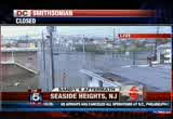
what's the situation this morning? >>reporter: good morning. in addition to the township of little ferry is included in that situation that you're discussing this morning. that's north and west of us. we're in seaside heights. that's in ocean county. it's about 45 miles north of atlantic city. we just got some new numbers in from the state of new jersey. we know 2.4 million people are without power, many more in new york and in connecticut. one of our largest utility companies, con-ed is calling this the worst storm in history. there are dozens, possibly hundreds of people on many of these barrier islands who are stranded and in need of rescue. you can see why. this rising flood water. here where we are, seaside heights, it's a barrier peninsula separating the atlantic ocean and a nearby bank. today those two have met, submerging many streets here, and we've just spoke with the toms river police department. they're on the other side of the bay. they tell us that they've had calls from several people this morning who are in need of rescue, who need them -- the
8:40 am

police department, emergency officials to come and get them. while toms river and some of these police departments simply can't get to them. you can see this fire department here in seaside heights surrounded by water on one side. we were with them last night. they were removing some of their vehicles from in front of where they were. we were on the boardwalk here in seaside heights when this hurricane hit. we sheltered in place with a business that was located on the boardwalk. they allowed us to stay indoors. when we got back to our hotel about 45 minutes to an hour later, some of the damage was done to our hotel. and just across, you can see the damage that's done to the anchor hotel there, the roof was ripped off by sustained wind gusts between 74 and 85 miles per hour with this category 1 hurricane, hurricane sandy. now, hurricane sandy moved further inland, but we're still getting just a minor bit of wind and rain that's happening here where we are here in seaside heights. so that's what we're looking at. there are many people who are coming home for the first time and this is what they're
8:41 am

seeing, their homes, their basements flooded. we talked to some people who are out on the boardwalk yesterday, a business manager, he told me that he was already dealing with thousands of dollars worth of damage. so we know that that number is going to be at least here in seaside heights and oactd hundreds of thousands -- in ocean county, hundreds of thousands of dollars, possibly millions of dollars. it's hard to know how much sandy will cost the state of new york, but we know as the sun comes up today, the cruelty of some of the damage this storm has afflicted, it's just now becoming clear. i'll send it back to you guys in washington d.c. >> those are extraordinary pictures. we wish you, dan, and everybody there the best as they deal with this flooding all across that island. sthawch. >> unbelievable. amateur and professional photographers braved sandy's wrath, assembling a pretty amazing gallery of images. >> all day yesterday we asked you to send us your pictures of the storm and its aftermath and today we are still sorting through all of them. dave ross joins us live from
8:42 am

the web center with some of the best and the most viral from social media. good morning, dave. >>reporter: good morning, tony and allison. yeah, exactly right, allison. we're still asking for you to send in your photos. all you have to do if you have a smart phone, if you have a droid, search d.c. weather. once you do that, you can download the fox 5 weather app as people have been doing in big numbers the last couple of days. again, you were able to track sandy's path. and, again, as you are seeing here, this is the wind and you can see the miles per hour associated by color, the blue being around 10 miles an hour, the green around 30, and so on and so forth. so we have some different things here, not just sandy, that you can track if you want to download that fox 5 weather app, but we've been talking about those pictures. there are many ways you can send them. you can hit the submit button and you can send them to the fox 5 weather app, you can do it the old-fashioned way. talking about some of those images, tony and allison, the photo gallery from some of the damage we saw at ocean city has just been remarkable.
8:43 am

we have that up now on our website. you can see some of these pictures and you've seen, of course, our reporters out there, lauren demarco and beth parker, everybody has been out there. it's been pretty dramatic images that they've had from ocean city and other places that we've been out covering this storm live throughout the last 24 hours. so, again, all you have to do is go to our website and you will see these photos. but we want to see what you are seeing as well this morning, so, again, we encourage you to do so. yes, the storm has passed through our area which is great, but, you know, you're waking up today and maybe you have a dramatic image that we haven't seen. so help us, kind of be our eyes and ears from wherever you are. that's the one thing that's changed, as we well know in the last couple years with social media, you've really been able to help us see other images that we can't get our camera crews too. so we applaud you and thank you for doing that. again, you can also tweet us at fox5weather. tony and allison, let's go back upstairs now. >> you get a much better sense of it when you see those
8:44 am

pictures. dave, thank you. all the damage left behind by sandy will lead to lots of questions about insurance and how homeowners can cover their costs. >> michael barry from the insurance information institute joins us live on the phone. he's here to help explain what happens next. good morning, michael, are you there? >> yes, good morning to you. >> for my first question, do most people have the type of insurance necessary to cover the losses that they've experienced -- that they've likely experienced, flooding damage, perhaps damage to a roof, that type of thing? >> well, the short answer is yes when it comes to wind damage. wind-caused damage is a standard coverage in a homeowner's insurance policy, so you're covered for, as you indicated, roof damage. flood is a different thing because flood is excluded from standard homeowners' insurance policies, but a lot of homeowners in fema-designated flood zones don't have a choice, they had to buy flood insurance, so they're likely to
8:45 am

be covered as well because flood insurance policy covers not only for a flood, but also a storm surge. the other coverage, you talked about falling trees, if a tree were to fall on a car, so long as you have comprehensive coverage and about 80% of the people, drivers opt to purchase it, you're covered on that as well when it comes to the auto insurance. >> an older car, like the one that i drive, though, will most of us just have liability and we're out of luck, right? >> i would say yes and i think that's why if you talk to insurance agents, they say if you're going to drop one on an older car, it's better to drop collision because collision is pricier than comprehensive and you have comprehensive coverage not only -- the answer is not just described with the tree falling on the car, but the comprehensive also covers you for a partial or submerged flooding of a vehicle. >> it's too late at this point if you haven't done the work
8:46 am

that you were supposed to do, the itemizing and all that, but what are you hearing today from your clients and what do folks need to do today? >> well, i think today, the first thing you want to do is if you have a safety issue, if you have an open roof, you want to try and cover it immediately. you also -- i know there's going to be a huge backlog, but you'll want to reach out to your insurance agent, your insurance company representatives. a lot of these companies have mobile catastrophe vans that are now going into the affected areas where hopefully you can just be a short ride away from an area where you can sit down and start the claims process with a professional from your insurance company. >> is the -- as people move forward -- allison just mentioned something, do you have to have taken all these pictures of your house before there was any damage or itemize your property and all that stuff, do you need to have had that? >> no, not really. i think it would be helpful, however, before the claims adjustor gets here to take your own photos of the damage and
8:47 am

that way that makes the claims process start easier because basically what the claims adjustor is going to be looking at are two main things. they're going to be looking at the dwelling damage and also the damage to your personal possessions possessions. the other side bar here, a standard homeowners' policy also has a provision if your home is uninhabitable, there's an additional living expenses coverage, a.l.e. which is listed in your coverage, a very generous coverage, pays your hotel bills, restaurant coverage for a specified amount of time such time as your home a habitable. >> that is good to know. we're short on time. one other quick question because it always comes up. if i've got a house and my neighbor's tree has fallen on my house, is that my insurance or is that his insurance? >> it's your insurance. the claims process starts with a tree -- where the tree landed and the insurance companies figure it out later if there had been an ongoing dispute about the tree not being
8:48 am

properly maintained, but wherever the tree falls, that's the person who is filing the claim to get it removed from the house, and that's really the key to it. where it is going to fall, that's who's filing the claim. >> easy to remember. michael barry with the insurance information institute. thanks for your time, sir, we appreciate it. >> good to see you. >> good stuff. >> sure is. >> that's a long process that starts now. it is 8:48 on this tuesday morning. much more still ahead. you are watching fox 5 morning news on a tuesday morning. we'll be right back.
8:49 am

hey! hey, baby. [ starts car ] were you eating smoked sausage in here? no! no. could have gotten me one. i did. try the unmistakable flavor of dunkin' donuts' smoked sausage breakfast sandwich. it's deliciously irresistible.
8:50 am

hurry in today. the smoked sausage breakfast sandwich is only at dunkin' donuts for a limited time. grab one today. when we think no one is looking. is what we do... mitt romney: believe that they are victims. anncr: mitt romney thought no one was looking when... he attacked forty-seven percent of americans. his companies shipped jobs overseas. his plan cuts millionaires' taxes, but raises yours. he'll voucherize medicare... and make catastrophic cuts to education. so remember what romney said... and what his plan would do. president obama: i'm barack obama and... i approve this message.
8:51 am

time for our facebook fan of the day. today we say hello to brittany wharton. brittany tells us today is her 25th birthday. happy birthday. [ applause ] >> all she asked for was her power to stay on. she didn't ask for much. hopefully she got what we wanted. so for your chance to be tomorrow's fan, just log onto our facebook page and leave a comment under brittany's picture. happy birthday. we've got reporters all across the region keeping our eyes on the aftermath of sandy.
8:52 am

among those is holly morris. she's been reporting live from annandale where there has been some damage out there. hey, holly. >>reporter: i said no power and we lost power. i will be careful what i say. us coming back online is a lot easier and a quicker fix than what this family is having to deal with. take a look across the street. we are live on gallows road and you can see a massive tree has fallen over onto these people's car and onto their home. obviously there's no power in this area. and as luck would have it timing wise, a tree service guy literally just pulled up, and he is assessing the situation right now as we speak. he said, you know, i'm going to give them a bid and see if i can get this tree off their house today. and that is important because if you are in this situation, you may not have a tree that big, but you might have some major debris down, be very careful. you don't want to try to do that yourself. there are professionals that know how to do it correctly, efficiently and most importantly safely. obviously if it's on a downed power line, that also is a very
8:53 am

dangerous situation. you don't want to find yourself involved in that. this is not a lone situation here in fairfax county, in fact, there are 53 trees down reported into homes in the county. so several people dealing with that. and there's still some other effects people are dealing with. let me give you a few numbers, 90 roads are still closed, 100 traffic lights still out. i can tell you, and that's driving around the county this morning. the traffic lights are not like clustered, all of a sudden you'll come upon an intersection where a light is out and people are forgetting that you really need to follow that four-way stop because the potential for accidents is great. 42 lines down. i already told you that 53 trees have fallen into homes and the thing is high tide in this area is not expected until 9:30 this morning. that's not that far away, but it's been raining all morning. so even though, you know, there's been a lot of talk about it not being as bad as it could have been, there is still the potential for flooding and potential problem areas for other people. we've seen a lot of things like this in terms of the power
8:54 am

outages like because on either side of these three homes, on the other side of this embankment, everything is fine and those houses have power and they're going on with their day. i will tell you this, fairfax county is asking that if you don't have to get out today, don't get out. schools are closed, government offices are closed. if you really can just stay in, it'll make everything a lot easier in terms of all the necessary people that need to be out dealing with the situation that they need to deal with. you know, we just came from an apartment complex where the roof had severe damage and all of those families had to be evacuated. they do have a shelter that is still open right now. there are 23 families that are taking advantage of that shelter, and they do have an emergency hotline. the fairfax county emergency information hotline is 571-350- 1300. it is still activated and will remain activated as long as there are residents that are having concerns they need to
8:55 am

deal with in the aftermath of hurricane sandy. 571-350-1300. i'm not sure, but i think the woman over there with the orange umbrella might be the owner of the home. i'll try to check in with her and try to get a read on how she's feeling today and what her plan is going to be. obviously hurricane sandy very difficult for that particular family. back to you in the studio. >> thank you, holly. coming up in our next hour, the show must go on, even when the audience isn't there. >> we're going to show you what happened during last night's late night talk shows, filmed in the middle of the storm in new york. it is 8:55. our team storm coverage continues next. anncr: seven-hundred-thousand jobs. that's what the plan george allen supports... would cost our economy. newspapers called it "economically destructive." like allen's votes to give tax breaks to companies... that ship jobs overseas, his economic plan would...
8:56 am

help big corporations, devastating the middle class. allen even voted against tax breaks for small businesses. virginia can't afford to go back to george allen. the democratic senatorial campaign committee... is responsible for the content of this advertising.


8:59 am

coast, killing dozens and flooding towns, destroying homes homes on fire. we have live reports this morning from virginia to delaware as the cleanup begins. and we may not be out of the woods just yet, as the rain keeping coming down, the flood risk continues, and some people are seeing snow. that's lauren demarco in ocean city, holly morris in annandale this morning. good morning, everybody, i'm tony perkins. >> i'm allison seymour. we begin our coverage this morning with breaking news in new jersey where hundreds of people are being evacuated after a levee break. >> we're told the entire town of moonachie, i believe it is, it's under water. people in a trailer park have climbed on their roofs and this is not the right video to go with that story. people in a trailer park have climbed on the roofs and are waiting to be rescued. there are no reports of any deaths
211 Views
IN COLLECTIONS
WTTG (FOX) Television Archive
  Television Archive News Search Service
Uploaded by TV Archive on
